The 75 best hikes in Eastern Canada
 Tweet
Tweet Share
ShareFrom Ontario to Nova Scotia, here are our favourites
Ontario's trails offer unique views and mostly navigable terrain. Stepping away from the crowded urban streets or exploring different scenes is easy to do thanks to the many trails that are not too far away from major metropolitan centres. If you're seeking nature and want to take a day trip, you'll want to explore this guide first.
Most of the trails in Ontario are provincial and require a day pass. During the time of COVID-19, this means buying your tickets online ahead of time (and some spots may require a specific booking time to avoid crowded trails). Most people won't be trekking to trails mid-week so plan ahead and enjoy these trails without the weekend crowds.
While the weather is still agreeable, take the time to explore Ontario's trails. Here's a look at some of the best places for a day hike in Ontario.
Dundas Peak Trail
Distance: 3.9km
Hiking time: 1 hour
Elevation: 110 metres
Located just 20 minutes from downtown Hamilton, Dundas Peak is located within Spencer Gorge Conservation Area. It is a beloved local lookout to the Niagara Escarpment and offers a fantastic little day hike ending with some great views. Take the trail along to the beautiful Webster Falls, then Tews Falls. The 3.9km trail ends at the gorgeous Dundas Peak lookout. Although the trail and lookout are beautiful in all seasons, it shines in autumn. The trail is also a pretty good workout if you put a little oomph into it.

Dundas Peak, ablaze with colour in fall
Ishpatina Ridge Tower Summit
Distance: 4km
Hiking Time: 2-3 hours
Elevation: 693m
Ishpatina Ridge is located in Lady Evelyn Smoothwater Park and is one of the shorter trails in this list. We like Ishpatina Ridge because it's mostly accessible for beginner hikers and even offers a great trail run option. The trail itself is only 4km (about 2 hours of your day) but comes with beautiful lakeside scenery and relatively smooth terrain. The trail is well marked but isn't landscaped so you can get that needed sense of getting lost without the need to leave a trail of breadcrumbs. If you have trouble walking, watch out for the second part of the trail that gets a bit steeper but isn't anything most people can't handle regardless of skill level. Check out the park's guide before you go.
MIzzy Lake Trail
Distance: 11km
Hiking Time: 6-8 hours
Elevation: 96m
Sometimes a longer trail with some rough spots is what you're looking for. When that mood strikes, the Mizzy Lake Trail may be what your soul needs. This trail stretches for 11km and includes many wildlife, small ponds, lakes, and plenty of tree-lined lanes. We don't recommend Mizzy Lake for people that have trouble walking as the trail does come with lots of rough spots, including tangles, roots, and rocks. This is one trail that will slow you down and demand you take a look around. You can find details on how to get to Mizzy Lake on this site.

One of many beaver ponds along Mizzy Lake Trail, Algonquin Park
White Bear Forest Trail
Distance: 20km
Hiking Time: 8+ hours
Elevation: 396m
The White Bear Forest Trail can be accessed from the road and boasts trees as far as the eye can see. This is an old-growth forest, which means that the trees in White Bear are in all aspects of life, from newer growth to fallen trees and dead trees that remain standing. Old-growth forests are ideal for a real escape and offer plenty of picturesque views (bring a camera). The shade on this trail is also unique as the sun filters through the trees differently depending on the tree height and life stage. The trail itself is well maintained and easy to hike, making it suitable for all levels. Learn more about the trail and its significance here.
Bruce Trail, Bruce Peninsula National Park
Distance: 21km
Hiking Time: 8+ hours
Elevation: 7253ft
The Bruce Trail in Bruce Peninsula National Park is one of the most scenic trails you'll find in the province. The trail stretches 21km, so make sure to arrive early and plan to spend the day hiking. Caves, cliffs, white beaches, and water that looks like a scene from the Caribbean await hikers that venture to Bruce Trail. This park is popular during the summer months thanks to the fantastic beaches and water access. Still, it's less populated and quieter during the fall when the weather is a bit cooler (making it an ideal place for a September or October trek). The trail starts easy and includes some wooden walkways but gets a bit more rugged as time goes by. You'll want to check out the park website for tickets and other details before you go.
Lake Superior Provincial Park trails
Distance: Various
Hiking Time: 2-10 hours
Elevation: varies
The Lake Superior Provincial Park is one spot that many Ontarians miss out on when it comes to hiking. The park is known mostly for being a great picnic spot, but it also boasts many welcoming trails to all skill levels. Cliffs, beaches, waterways, forests, and fantastic Fall views are some of the reasons why the trails in this park are sought after by hikers in the know. We didn't pinpoint a specific trail in this park because there are so many to choose from (especially if you want to canoe part of the trail you pick). We recommend visiting the park's website to find out more about the various trail options and to purchase park passes in advance. The Lake Superior Provincial Park is open until Oct. 25.
Bluff Trail, Awenda Provincial Park
Distance: 8km
Hiking Time: 2-4 hours
Elevation: 899ft
Bluff Trail is not a difficult trail full of treacherous terrain, but it's a great way to spend a few hours of your day, and it's family-friendly. Bluff Trail is an ideal way to experience some of Ontario's famed old-growth forests. This trail is perfect on a spring day, but it also offers Fall visitors some excellent scenery. The trail is well-maintained and comes with plenty of walkable paths. There are other trails in the park that are more challenging, but this is one of our favourite simple trails. To find out more about Bluff Trail and Awenda Provincial Park, check out the park's website.

Sunset in Awenda Provincial Park
Pretty River and Bruce Trail loops, Pretty River Provincial Park
Distance: 9km
Time: 1.5 hours
Elevation: 500m
This trail offers the best of this stunning location that winds through a beautiful forest alongside a scenic little waterway. This is not an immensely popular park since there is no parking lot or facilities. Park-goers must park alongside the road and access hikes at various points along the way. There is a wide variety of trails from which to choose, but watch out for mountain bikers who also enjoy the area. The park includes portions of the Bruce Trail and the Niagara Escarpment system and is included in the Niagara Biosphere Reserve.
Silhouette Trail, Killarney Provincial Park
Distance: 73km
Hiking Time: 1-3 days
Elevation: 8000ft
The Silhouette Trail isn't exactly a day-trip, but it is worth adding to this guide because it provides a real break from everyday life and comes with fantastic scenery. If you have a long weekend or want to take a day or two off work, head to Killarney Provincial Park to explore the Silhouette Trail. This trail comes with views of the White Quartzite Hills that are part of the La Cloche mountain range. You'll also pass by various lakes and other bits of water while hiking a challenging trail that is anything but boring. The park does offer camping options (book ahead online), and there are facilities available. Book before you go here.
Scenic view, Killarney Provincial Park
Silver Peak, Killarney Provincial Park
Distance: 6km
Hiking Time: 3-4 hours
Elevation: 543m
Silver Peak in Killarney Park is an expedition camping trip that will require a canoe. If you're up for a challenge, canoe to the trailhead via Bell Lake of Johnny Lake. You can leave your canoe at the trail entrance and follow the signs for Silver Peak. The trail is relatively flat but does creep up in elevation towards the middle of the course, and you will be climbing for almost an hour to reach the peak. At some points, the trail can get slippery and does require proper footwear (don't attempt this one with running shoes). Silver Peak was once the future spot of a ski mountain, but the plans fell through, resulting in a rugged trail for hikers to explore. Leave a full day to check out this trail, and be sure to read more about the terrain before you go.
Riverside to Wilderness trails, Pinery Provincial Park
Distance: 4km
Hiking time: 2 hours
Elevation: Minimal
This unique and pretty trail winds through oak savannah, mixed pine and oak forest, sand dunes, wetlands and along a river. It's got a bit of everything. This birding mecca also provides many wildlife viewing opportunities of the avian variety in addition to numerous varieties of mushrooms, reptiles and more.

Wilderness Trail, Pinery Provincial Park
Peat Mountain, Lake Superior National Park
Distance: 11km
Hiking Time: 3-5 hours
Elevation: 1620ft
Rabbit Blanket Lake Campground is the access point to Peat Mountain in Lake Superior National Park. This trail will take you through a mixed forest and somewhat rocky terrain to the top of the mountain. Once you get to the top, you'll want to stop and look around (pack a picnic lunch). If the weather is clear, you can see Michipicoten Island nestled in Lake Superior. If you want to make it an overnight trip, there's a campground at Foam Lake (book ahead online). Details and booking information can be found here.
La Vigilance Trail, Renee Brunelle Provincial Park
Distance: 5km
Hiking Time: 1-2 hours
Elevation:
If you're a history fanatic, you'll want to take a day trip to La Vigilance in Renee Brunelle Provincial Park. The hike itself is a relatively easy 5km hike that offers a decently maintained trail easy enough for all skill levels. Still, the real gem of La Vigilance is the historical significance of Airplane Island which can be seen from the top of the trail. Airplane Island was established during the 1920s as a base for airplanes used to extinguish forest fires. The park's main website contains additional information about the island and the trail.

Arrowhead Park
Stubb's Falls Trail, Arrowhead Park
Distance: 2km
Hiking Time: 1-2 hours
Elevation: 229ft
Waterfalls are underestimated but are worth a quick 2km hike to see. The Stubb's Falls Trail is a great day-trip destination and an opportunity to sit by the falls and picnic, read, reflect, or hang out with a friend. This is also an ideal trail to choose if you want to bring kids on a quick trip immersed in nature or take a break for a few hours. During the fall months, Stubb's Falls provides an ideal opportunity to view tree colours. Check out more about the trail and how to get there here.
Fire Tower Trail, Restoule Provincial Park
Distance: 7km
Hiking Time: 3-8 hours
Streams, ponds, and lots of fall forest colours are what you'll find when exploring the 7km Fire Tower Trail in Restoule Provincial Park. The trail ends above Stormy Lake, where you'll have the opportunity to gaze at clear waters and take a look at the still existing fire tower that's perched on top of the mountain. This trail is marked moderate because there are various steeper parts of the trail and some slippery spots. You'll want to pack light and wear hiking shoes for this one. Find more information on the park's website.
Pines Hiking Trail, Quetico Park
Distance: 10km
Hiking Time: 5-8 hours
Standing at the base of an ancient pine tree can help you gauge your place in the universe, and Pine Hiking Trail doesn't disappoint when it comes to towering trees. This trail stretches for 10km and comes with some rougher knotty parts, but it is worth taking all day to explore. You can also head to Pickerel Lake for a beach day or pack a picnic and spend it under the pines. You will have to reserve a pass online before you go, so make sure to plan accordingly.
McCarston's Lake, Carriage and Spillway Trail, Mono Cliffs Provincial Park
Distance: 9km
Hiking time: 1.5 hours
Elevation: 100m
This trail is a lovely but busy loop through a beautiful slice of forest and cliff that sits on the Niagara Escarpment about an hour north and slightly west of Toronto near the town of Mono Centre. There are lovely woods here, water features, and all manner of rocky formations that are unique. It is just far enough away from the city that it isn’t always overrun by city dwellers, but it does get busy on the weekends so choose trails that lead furthest away from the central area to avoid those just out for a quick stroll with the dog. There is a great inn with a delish restaurant and patio for a refreshing drink or snack after the hike.

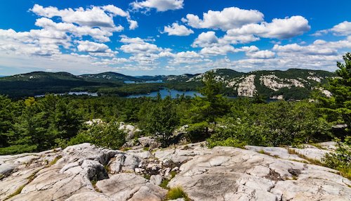
Algonquin Park's Centennial Ridges Trail
Centennial Ridges Trail, Algonquin Park
Distance: 10km
Hiking time: 4.5 hours
Elevation: 460m
Centennial Ridges Trail is a well-known and beloved loop trail around a lake and is rated as difficult. There are some very rewarding views thanks to two high ridges, some of which are considered the best in this incredible park, and that's saying something. It can be muddy. The views in awesome are epic.
Goblin Lake Trail, Blue Lake Park
Distance: 11km
Hiking Time: 5-8 hours
Elevation: 159m
The Goblin Lake Trail follows the edge of Goblin lake and is both scenic and rugged. The lake's borders can be muddy and may include some rockier points making proper footwear necessary. This trail is marked clearly for a reason: it's easy to get lost while exploring the Goblin Lake Trail. But, if you follow the signs and stay on the main path, this is a great hike that's ideal for a day trip. The trail is marked moderate by the park system and is best suited for hikers with some experience (not a great trail for smaller kids). Check out the Blue Lake Park website for additional tips.
Silver Queen Mine Trail, Murphy's Point
Distance: 2km
Hiking Time: 2-3 hours
Elevation: 22ft
Ontario has many historic trails that aren't incredibly difficult when it comes to skill level but offer plenty to explore. The Silver Queen Mine Trail is a short 2km trail that's well maintained and isn't a challenge to hike. This trail's beauty is the mica mine that was fully operational during the 1900s and remains partially open today. The mine can be explored by hikers (popular with kids), and the trail also has a restored miner's bunker house along the way. If you want to leave the city for a day and bring the whole family, the Silver Queen Mine Trail is a great way option.
Bass Lake Trail, Bass Lake Park
Distance: 2km
Hiking Time: 2-3 hours
Elevation: 114ft
You'll need to find something to do with the family on those more extended fall weekends, and the Bass Lake Trail might be what you're looking for. This trail is smooth, easy to trek, and comes with something entirely unexpected by most: a working farm that has been in its current location for more than 100 years. The Rowe Farm Homestead is an excellent reminder of what life once was for most Ontarians and what it remains for the farm owners. Kids will love this hike and exploring the farm's land and animals.
Walk of the Little Bonnechere River, Bonnechere Park
Distance: Various Lengths
Hiking Time: varies
Bonnechere Park is one of the lesser-known Ontario parks, but it's worth exploring if you have some time to kill and want to try something a bit different. The Walk of the Little Bonnechere River is a compilation of 10 trails of varying lengths. Some of the trails are more difficult, but none are incredibly rugged. The trails provide a great view of the Bonnechere River and are an ideal way to spend the day water-side. The trails at Bonnechere Park are well-marked and maintained, and you can pick up a map at the park's entrance. Some more details about the path can be found on the park's website.

White River Suspension Bridge in Pukaskwa Park
White River Suspension Bridge Trail, Pukaskwa Park
Distance: 18km
Hiking Time: 5-8 hours
Elevation: 15m
The White River Suspension Bridge Trail is not for the faint of heart, but it is a trail that you have to try if you have some hiking experience. As the name suggests, this trail is a large part suspension bridge that stretches across 23 meters above Chigamiwinigum Falls. The bridge sways and swings making it fun to trek across but also heart-pounding. Before reaching the bridge, you'll cross wetlands, swimmable waters, and plenty of picnic spots. Spend the day and enjoy all that Pukaskwa Park has to offer -- campsites are also available through the park's main website.
Nipigon River Recreation Trail
Distance: 10.1km
Hiking Time: 3-6 hours
Elevation: 675ft
The Nipigon River Trail is a well-maintained and landscaped trail that is slightly challenging to beginner hikers. The trail comes with some steep steps, various wooded lookouts, and the Nipigon River (part of Lake Superior). There are some shorter entrances to the trail starting at the Red Rock trailhead. A clear map and details about the park are worth looking at before you head to the Nipigon River Trail.
Quebec
Quebec is known for its cities and old-world charm, but not far from the bustling metropolitan areas and delicious restaurants are some amazing hiking trails just begging for a day hike. A combination that makes Quebec an incredible weekend getaway spot.
The province boasts rugged shorelines and tons of wooded trails only slightly inhabited by humans. It's easy to get lost on some of Quebec's best hikes, effectively stepping away from it all. The province has mapped out most of the trails in its national parks through the SEPAQ website.
Most paths do include park admission fees that should be paid ahead of time via the SEPAQ website. If French isn't your first language, it's good to bring a guidebook with you as some of the areas listed here are mostly French, and English will be scarce.
Here are some of our top picks for day hikes in the land of the Fleur de Lis.
Pingualuit Crater Rim
Distance: 13km
Hiking Time: 3-5 hours
Elevation: 230 meters
The Pingualuit Crater trail includes a massive crater lake that locals call "The Crystal Eye of Nunavik." The crater itself is part of the Pingualuit National Park, an 82-kilometre protected wildlife refuge. There are no real trails at the park, but you can find your way around the crater rim or try the loop from the crater to the north campsite and back (about 70km). This area is only accessible in the spring and summer, and it's suggested that you book a tour with a local group before attempting to access the restricted area. It may take some planning to get to the Pingualuit Crater and its various hikes, but it's well worth the trek.
Deux-Criques Trail
Distance: 15.3km
Hiking Time: 5-7 hours
Elevation: 2,037 ft
If you enjoy adventure, Shawinigan's Deux-Criques Trail in La Mauricie National Park in the Laurentian Mountains is the perfect find. To cross this trail, you'll have to ford a brook and trek through some gnarly bits of land. The trail is relatively quiet during the fall and spring with some lighter traffic during summer months. Deux-Crique is popular with bird watchers and affords some amazing wooded fall views. This trail is challenging, with lots of ups and downs and some very rocky parts. This isn't a great trail to take with younger kids or inexperienced hikers, but it is the perfect full-day hike if you have great weather and a nearby campground.

Outremont Summit, Montreal
Distance: 10km
Hiking Time: 3-5 hours
Elevation: 211m
Montreal's Mont-Royal deserves to be part of this guide because it's smack in the middle of the city and affords some of the best city views while enjoying a serene natural setting. There are also parts of Mont-Royal that are mostly unknown to tourists and locals (partly because the mountain is so vast), making it the perfect getaway if you are visiting Montreal or want to escape the city streets. Most people know about Beaver Lake and the central mountain trail, but few take the time to explore the other side of the mountain dubbed "The Outremont Summit." This part of the mount includes a rocky and steep 10km trail that winds around the hill and consists of a lookout that was once a ski hill (remnants of the ski lift remain and make a perfect tower perch worth climbing). Parts of the summit trail are perfect for inexperienced hikers, but if you sneak your way up the mountain (and we recommend that you do), you'll find fields of wildflowers and rocky ledges that will test your trekking skills.

Vallée Bras du Nord
Distance: 80+ km
Hiking Time: varies according to trail
Elevation: varies
Vallee Bras du Nord offers hikers more than 80km of pristine hiking trails. Because these trails are well-maintained and manicured, there's a hike for every ability. There are plenty of shelters, stops, and facilities throughout the trails in this network, too, so it's not a destination you'll want to seek if you are looking to carve your way in or out of wild trails that haven't seen footsteps in a while. But if you're looking to set off on a day trip and explore nature without roughing it, this is an excellent network of trails to consider. The Philosore trail is the longest one in this network spanning 28.1km but is also the most difficult. Beginners will find the Beaver Trail much more manageable at 6.9km. Keep in mind that you will have to purchase a day pass online before you leave.
Sentier Iroquois, Duhamel
Distance: 6.9km
Hiking Time: 3 hours
Elevation: 259m
Some Quebec hiking trails are only known by locals or people that frequent areas during summer months. Sentier Iroquois in the Outaouais region of Quebec is one such trail. This mostly unknown area is a haven for hikers and trail runners because it is quiet during the loudest months of summer. This isn't the hardest or longest trail, but it is an excellent break from the heat, and it does come with plenty of trail challenges, including some steep and rocky parts. The trail is rated beginner with some intermediate sections and is a great way to step up your hiking game if you just started (or to strap on some trail running shoes and try your luck and running through rocky paths).
Parc National du Bic
Distance: varies
Hiking Time: varies
Elevation: varies
Parc National du Bic ("Le Bic") is where land meets water and offers one of Quebec's best breaths of nature. Located on the St. Lawrence Seaway, this national park includes plenty of traditional landscaped trails accessible to all ages in addition to a coastal pathway that's only accessible during low tide. There are 25km of trails at the park with many beginner and advanced options. Le Grand Tour is one of the park's hardest trails with cliffs overlooking the sea and plenty of steep ledges, but it's also short at 8.7km. There's also a handful of beginner trails spanning 1.3km to 10km. Be sure to book a campsite, yurt, or cabin to have someone to crash for the night as pitching a tent trailside is frowned upon.
East Point National Wildlife Reserve
Distance: 4.5km
Hiking Time: 1-2 hours
Elevation: 62 ft
If bird-watching is your reason for day-tripping, Isles-de-la-Madeline's East Point National Wildlife Reserve is the place to be. This 684-hectare bird sanctuary offers two trails: La Camarine and L'Échouerie. Neither path is particularly hard, but L'Échouerie is the more difficult of the two. These trails can be accessed with a guide (to help you spot and seek out wildlife) or on your own through the Route 199 entrance. The total distance between the two trails is 4.5km, making it ideal for a slow and easy hike on a cooler day. There's nowhere to stay onsite, but there are plenty of rental options in the area.

The Gorge Canyon Trail, Coaticook
Distance: 3.5km
Hiking Time: 1.5 hours
Elevation: n/a
Hikers flock to the Gorge Canyon Trail in Coaticook, Quebec, for one reason: the longest suspended footbridge in North America. Built by Couillard Construction in 1988, the bridge is a massive draw in the summer months. The footbridge is only accessible in the summertime and only through the Sentier de la Gorge trail. The trail itself is 3.5 kilometres and is an easy trail idea for beginners that aren't afraid of heights. A more advanced trail option that doesn't include the footbridge is the Sentier Tillotson trail that spans 8.5km.
Grand Prix des Couleurs, Mont Tremblant
Distance: 5.5km
Hiking Time: 2 hours
Elevation: 645m
Mont-Tremblant is another popular destination in Quebec but also one that comes with some stellar trails worth a day trip. Sometimes getting to the top of the mountain requires the most direct path, and that's what the Grand Prix des Couleurs is: a straight shot from the base to the summit. Because the trail is so steep, it's labelled an advanced path and is strenuous despite appearances. The trail itself is 5.5km, but don't let that distance fool you -- this is not an easy hike. Technically, it will take you around two hours to get to the top of the trail, but many have taken much longer due to the path's never-ending incline.

Le Grand Tour Trail, Yamaska
Distance: 18.4km
Hiking Time: 2-4 hours
Elevation: 620m
Quebec's Eastern Towships are best known for sprawling summer lake houses, but this part of the province also includes the Parc Nationale de la Yamaska and its lengthy Le Grand Tour trail. This trail will take you through 18.4km of beautiful nature preserve complete with wooded areas and plenty of fresh air. The trail is ideal for beginners and families but maybe too long for younger hikers. Dogs and mountain bikes are welcome along the trail, making it the perfect spot for a day trip if you're in the townships or just passing through.
Cavalry Hike, Oka
Distance: 4.4km
Hiking Time: 1.5 hours
Elevation: 328 feet
Oka is home to several trails, but the Cavalry Hike (Calvaire d'Oka) is one of the best ways to see wildlife and explore it without relying on well-travelled and marked paths -- which is a bonus to some hikers seeking a rougher route. While the trail is marked moderate and is accessible enough for beginners, it's a steep up-and-down route that doesn't disappoint. The Cavalry Hike is also a great trail running option with plenty of room to run on the broad path. There are three chapels on the trail, making it a fun step into the past and a great place to explore. Be careful when descending the trail as markers are not indicated, making finding your way back to the parking lot a bit tricky (but doable).
Sentier Notre-Dame, Kapatakan
Distance: 215km
Hiking Time: 13-15 days
Elevation: various
The Sentier Notre-Dame Kapatakan trail is part of a pilgrimage route that winds its way from the Parc National du Fjord-du-Saguenay (Saguenay Fjord Park) to L'Ermitage Sant-Antoine de Lac-Bouchette. The trail begins amidst granite cliffs, winds its way through an urban river landscape, and ends in a lush forest. There are few trails with scenery as varied as this one making it a popular destination with hikers seeking breathtaking views and a unique trail challenge. The terrain is moderate and can be enjoyed by all levels. You can choose to follow part of the trail for a few kilometres or bring your camping gear and set up overnight (you'll want to grab a trail guide if you decide to do this) covering 20kms per day. Bridges, wooded walkways, religious statues, and other relics await hikers that day trip to Kapatakan.
Les Cascades Trail
Distance: 4km
Hiking Time: 1-2 hours
Elevation: 100 ft
Les Cascades is a 4km trail near Stoneham-et-Tewkesbury in Shawinigan, QC is a picturesque trail that's an excellent start for new hikers. Some people have noted that the trail isn't the best option for younger kids due to rocky terrain and steep parts. Still, it is a great way to explore this part of the province, view fields of wildflowers, and enjoy views of cascading streams -- a great way to clear your head if the city landscape becomes too much and you need a quick break. Because the trail is only 4km, it doesn't take long to complete (about an hour without frequent breaks), but it's recommended that you stay and linger on this trail as long as possible to take in all the surroundings have to offer. You'll want solid trail shoes for Les Cascades as it can get rocky in parts. Make sure to stop and sniff the pines on your way!
Les Crêtes, Mont Orford
Distance: 18.7km
Hiking Time: 9 hours
Elevation: 853m
Mont Orford in Quebec's Eastern Townships is known for its skiing hills during the winter months, but hikers have long known that the Les Cretes trail is the perfect spot for a long and rugged hike during warmer seasons. This is a mountain hike, so expect high elevations, steep rocky terrain, and flatter and simpler parts. Start at the North Stairs (Escalier du Nord) and head towards the Pic de la Roche-Fendue, where you'll see amazing views of Lake Stukey. From there, trek to Pic de l'Ours lookout where you'll be able to see the entire region before you (a great spot for photos). La Grande Coulée trail will take you back to the ski centre where you can head down the mountain and back to your car or rest and relax. This trail is complicated and is not recommended for small children or beginners.

La Croisée, Parc National De La Jacques-Cartier
Distance: 12.3km
Hiking Time: 4.5 hours
Elevation:
Hikers seeking an all-day adventure should head to the Parc National de la Jacques-Cartier (Jacques-Cartier National Park) in Stoneham-et-Tewkesbury, Quebec. There are a lot of trails that are accessible through this national park. Still, La Croisee is one of our favourites because it is longer, has intermediate terrain with breathtaking views, and isn't the most popular route in the park, making it less travelled (and a bit more serene than other trails in the park). You'll hike through deep gorges on this trail and encounter some rougher parts, but the trail is well-marked and makes for a great day trip if you're in for a few kilometres. There are plenty of bed and breakfast options in the area if you want to make the park a weekend adventure.
Le Courir des Bois, Duchesnay
Distance: 16.1km
Hiking Time: 5.5h
Elevation:
Here's one for the trail runners: Le Courir des Bois in Duchesnay isn't for the faint of heart, but it is an unusual running path and hiking trail that's entirely carved by nature. Located in the Duchesnay region, Le Courir des Bois is precisely how it sounds: a run through the woods. There are technically over 20kms of trails in this region, but the "woods run" will put your trail shoes to the test with 16kms of rocky hills to help you build endurance. Because this trail is rough (and we're not saying that lightly!), it's not a trail to try if you are new to trail running or don't have the right gear. However, it is one of the best options if you're somewhat experienced and looking for a serious run or strenuous hike.

La boucle du Sentier des Escarpements, Parc National du Mont Megantic
Distance: 6.7km
Hiking Time: 2h
Elevation: 650m
Mont Megantic is home to Quebec's ASTROlab and is a must-see destination for all levels. You can visit the lab and observe the stars during the daytime or during special evening hours, but the park itself boasts several trails that seem to connect the earth and the sky. One of the most popular trails with intermediate hikers it La boucle du Sentier des Escarpements, which is a 6.7km trail in the park's relatively new Franceville sector. You'll experience stretches of moss and lichen, panoramic views, and massive boulders along the way. The trail will take roughly 2 hours to complete and is a great way to explore the area between the Canadian and US border. Surrounded by a ring of mountains and streams, this trail is ideal for most hikers with some experience.
Acropole-des-Draveurs trail, Malbaie
Distance: 9.6km
Hiking Time: 3-4h
Elevation: 875m
The Acropole-des-Draveurs trail near Saint-Aime-des-Lacs in Malbaie, Quebec, is one of the best-known spots to stop and enjoy wild blueberries or pick some edible mushrooms (if you know what to look for!). The trail features three summits, with the top being the most popular option. While the views from the top of this trail are incredible (and, honestly, one of the best prospects in the area), the trail itself is quite popular, making it crowded on summer days. If you want to explore Acropole-des-Draveurs and all it has to offer (and recommend that you try it out at least once), it's a good idea to go early and head back just as crowds are coming in. The trail is rated difficult but is mostly long rather than hard and can be enjoyed by anyone seeking to put in a few hours of work.
Frontier Trail, Mont Gosford
Distance: 8.9km
Hiking Time: 4h
Elevation: 1883ft
Mont Gosford offers the highest peaks in Quebec. Suppose you've travelled to Maine in the United States. In that case, you might be familiar with the other side of this mountain called Katahdin, a popular hiking spot for serious trekkers throughout New England (and features some trails that are reserved for skilled climbers). Mont Gosford is part of the White Mountain chain and is one of the best spots for experiencing some serious height in the province. You can easily go off-trail at Mont Gosford, but one of the most popular options is the Frontier Trail (FS6). This trail includes a stunning waterfall and is moderately trafficked but remains a solid advanced trail due to its rocky and steep terrain.
Les Graves, Forillon National Park
Distance: 8km
Hiking Time: 4h
Elevation: 80m
If you start at L'Anse-aux-Amérindiens and continue on Les Graves, you'll be hitting the last leg of the larger trail that totals about 8km up and back. If you want a bit more of a challenge, take Les Graves starting at Grande-Grave for 15.2km. The shorter part of this trail is included in this list because it comes with one of the most beautiful land and sea views we've seen. When you reach Cap-Gaspe, you'll see a lighthouse that is now entirely powered by solar and is wholly automated but once was manned by a lighthouse guard. The lighthouse is perched atop a 95-meter-high cliff that overlooks the sea, and we can't think of a better way to spend the day if you have a few hours to kill and are in the Gaspe area.
Canyon Saint-Anne, Beaupre, QC
Distance: 3km
Hiking Time: 1h
Elevation: 80m
Sometimes hiking on your own isn't doable, and for those times, a picturesque trail that's not overly difficult is the best option. If you find yourself near Quebec City and need some nature, Canyon Saint-Anne will give you the peace of mind you're seeking without requiring a 4-day trek. This canyon features suspended footbridges that traverse the canyon's gorge and are not for the faint of heart. Because the path is well-travelled and wide, this is an excellent option for beginners or families with kids. You'll enjoy a leisurely hike and amazing views, and if you're still feeling adventurous, you can jump on a zip line and fly through the forest.

Le Tour du Mont Albert
Distance: 17.8km
Hiking Time: 7h
Elevation: 870m
Mont Albert is part of the popular Chic Choc range in Gaspesie National Park. Le Tour du Mont Albert is the longest trail in the park, making it the hardest. The trail will take you through the summit before reaching the plateau, and then it's a very steep way down to the Grande Cuve. Once you descend, rocks will greet you as you make your way to the Serpentine shelter (you'll need a pause once you reach this point!). The trail and park are home to many caribou, and Quebec protect the caribou population by closing the trail on September 30, so make sure to head to Gaspesie before October begins. Because the park is also a wildlife preserve, you'll want to bring a camera to capture some close encounters with the park's inhabitants.
La Roche, Mont Tremblant
Distance: 5.4km
Hiking Time: 3h
Elevation: 454m
Mont Tremblant is home to a lot of trails, including La Roche, an intermediate trail spanning just over 5km. The trail itself is well-maintained and travelled but does come with some spectacular views of Lake Monroe. If you're in the Tremblant area during the fall months, La Roche is a particularly lovely hike that affords some fantastic views of green and gold leaves high atop the lookout. This is a trail that you can do with kids, older hikers, and if you're starting out or want a leisurely hike that will make you sweat but won't require any hiking gear. Plenty of accommodations are available in the Mont Tremblant area, and parking is plentiful though you will have to pay to access the mountain and its trails.
La Baie Trail, Charlevoix
Distance: 11.9km
Hiking Time: 3h
Elevation: 850m
Charlevoix is a popular destination for whale watchers, but few know of its hiking trails. La Baie trail extends across Baie-St-Paul and comes with some great views of the backcountry at the start. Once you're through the first few kilometres, you'll find yourself immersed in a lush forest where you may be tempted to sit down and reflect for a few moments or hours. Footbridges, wooden walkways, and plenty of wildlife can be seen on this trail. The trail itself is marked intermediate due to some steep inclines and declines, but it's so strenuous that you can't make it if you are new to hiking. At 11 kilometres, La Baie is also a decent workout.
Mont Des Morios Loop
Distance: 25km
Hiking Time: 8h
Elevation: 500m
Notre-dame-des-Monts is located in the Charlevoix region and is home to one of the longest trails in the area, the Mont Des Marios Loop. This trail's loop configuration makes it relatively easy, but it is still a strenuous trek due to its length. That said, the path is worth seeing for its waterfall, lush woods, and incredible viewpoints. If you have a full day to kill and need fresh air, the Mont Des Morios Loop is a great way to spend a fall or summer day. Be aware that hunting is permitted on the trail and in the area in general. Wearing bright colours during hunting season is a must when visiting the Mont Des Morios Loop.
Canada's Maritime provinces are some of the country's most stunning. But, it isn't just about gorgeous ocean views, whale watching and other aquatic pursuits, the Atlantic provinces also offer some of Canada's best-hiking spots. We've combed through trails ranging from novice climbs to mountains best preserved for advanced hikers to come up with 25 of the best places to hike in the Maritimes.
Grab your gear and get out there!
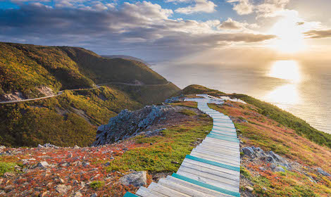
Black Head Path
Hiking Time: 1-2 hours
Distance: 3.7km
The Black Head Path in Newfoundland would be a novice trail if it weren't for the elements. Because of this trail's location, wind, rain, and other weather tend to be harsher than average. If you decide to trek to Black Head, make sure to pack for the weather and dress in layers (proper hiking boots are necessary). Older kids can enjoy this trail as well as intermediate hikers. You'll see lighthouses, experience cliffs, and have the opportunity to enjoy some breathtaking views. The website for this path is sometimes updated here.

Black Head Path, Newfoundland (Photo credit: Barrett & MacKay Photo)
Fundy Footpath
Hiking Time: 4-5 days
Distance: 50km
Although this iconic multi-day hike is one of the tops in the province of New Brunswick and is considered by many to be one of the best in the entire world, so it is worth it to take note, make a plan, and tackle this challenging beauty when proper preparations have been made, which must include essentials such as navigational aids since cell service is unavailable in spots. The Fundy Footpath, complete with stunning lookouts, beaches and waterfalls, runs almost 50 kilometres from Big Salmon River Road to Fundy National Park.
Greenwich Dunes Trail
Hiking Time: 4 hours
Distance: 4.8km
Walking over a floating boardwalk is a surreal feeling that you have to experience at least once. Greenwich Dunes Trail on Prince Edward Island is not only a beautiful trail to climb, but it's also one of the few tracks you'll find with a boardwalk that floats over the water. This trail is well maintained and is not complicated, making it ideal for kids, beginner hikers, and seniors. Some weather conditions may impact the dunes' opening hours, so check the site before you go.
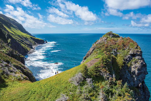
Cape Split Trail
Hiking Time: 4-5 hours
Distance: 8km
Nova Scotia's Cape Split is an eight-km trail, and a 16-kilometre trail if you make the full loop. Either way, it's a popular hiking trail despite its length because it offers incredible views. You'll see a panoramic view of the Bay of Fundy and experience the ocean air as you trek through the maintained paths. This trail can be tricky during the fall and winter months because it can get a bit muddy, but otherwise, it's an easy trail to explore. You will want to be on the lookout for any trail closures and notifications before you go.
Skyline Trail
Hiking Time: 2-3 hours
Distance: 6.5km
The Skyline Trail at Cape Breton Highlands National Park is an easy climb and is worth checking out if you are a beginner hiker or want to get the kids outside. Viewing decks offer an overview of the St. Lawrence, where whales love to play. The trail is well maintained and is a beautiful way to spend a warmer day. There are quite a few steps integrated into the Skyline trail, making it one of the more accessible hikes on this list. For more details, check out the park website here.
Skyline Trail (Cape Breton Highlands National Park
Clyburn Valley Trail
Hiking Time: 3-4 hours
Distance: 8km
This Cape Breton trail is unique because it is built on top of an abandoned gold mine. The fact that you'll be walking on part of history is a good enough reason to go to Clyburn Valley, but the trail itself also offers some exciting elements. Lots of giant boulders line the path and provide plenty of picnic spots in addition to some great rocks to climb for a better view of the area surrounding the valley. Kids love this hike, and it's also fun for adults. Visit the park website before you go to make sure the trail is open and accessible.
Walton Glen Gorge
Hiking Time: 4 hours
Distance: 4km
This beautiful trail in New Brunswick winds down a gorge and along a stream to a gorgeous waterfall. It's easy in some spots but moves into more risky terrain over rocks when approaching the 44-metre Walton Glen Falls. The hike proceeds through a narrow 10-metre rocky gap dubbed the Eye of the Needle where hikers would need to wade through water to keep heading along the Little Salmon River towards the Fundy Footpath. Stunning stuff. For further information go here.
Liberty Lake Trail (Kejimkujik National Park)
Hiking Time: 7-8 hours
Distance: 12km
Sometimes a walk around a large and gorgeous lake is what's needed, and Nova Scotia's Liberty Lake Trail doesn't disappoint. With views you'd expect from a 12km lake trail, this hike is easy enough to navigate but powerfully delivers on scenery and serenity. Plan to spend the day hiking through Liberty Lake, and don't rush -- there are plenty of places to stop for a picnic along the way. You can find more details about this hike here.
Pennant Point Trail, Crystal Crescent Beach
Hiking Time: 4.5km
Distance: 3 hours
Grab your pup and head to Pennant Point Trail, located in Crystal Crescent Beach. This trail loops around Crystal Crescent and touches upon some of Nova Scotia's loveliest beaches, allowing you to explore the beach areas during the offseason. The trail is open during the fall and winter and the warmer spring and summer months. Since Pennant Point is a well-maintained loop, you can easily traverse this trail when the snow starts to fall. For a trail map and other details, visit the main site here.
Coastal Trail (Terra Nova National Park)
Hiking Time: 2-3 hours
Distance: 9.5km
The Coastal Trail at Terra Nova National Park is a popular option, but one that's worth checking out for the jellyfish you'll see floating in the water below the highest peak. The Coastal Trail isn't rugged and doesn't require any serious hiking gear, but it has a few steep climbs that you'll need some skills to traverse. Intermediate hikers will fare well with this trail, but you will want to check for opening details on the site before you go. Warning: the path is open to hunters throughout the year, so make sure to wear bright gear!

Photo: Parks Canada / Dale Wilson
Salt Marsh Trail (Halifax)
Hiking Time: 6-7 hours
Distance: 8.7km
Salt marshes, wooded areas, and a gorgeous boardwalk make this well-traversed trail a fan favourite. Even though the trail itself isn't an incredibly challenging trek, it is still one worth doing if you happen to live in Halifax. The course used to be a railroad and is now a national park that's popular with people of all ages. This is a trail you can explore if you are new to hiking and enjoy it if you are experienced.
Osprey Trail
Hiking Time: 1.5-2 hours
Distance: 5km
Looking for a place to get away from it all, and commune with nature, it might be hard to beat this lovely and easy hike at New Brunswick's Kouchibouguac National Park. This forested trail goes through a pretty forest with interesting tree species before hitting the lagoon and saltwater marsh area of the Black River Peninsula, a birder's paradise where hikes will have a chance to spot birds including osprey, of course, and bald eagles diving for fish.
Duncan's Cove, Chebucto Peninsula
Hiking Time: 5 hours
Distance: 8km
We love hikes off the beaten path, and Duncan's Cove in the Chebucto Peninsula doesn't disappoint. Since this trail is located on a wildlife preserve, it is unmarked and nowhere near maintained, which means you have to hike cautiously. You'll encounter rocks (lots of them) and some treacherous footing near the coastline. Despite being a rugged hike (definitely not for kids or beginners), it's a path worth taking for the breathtaking views alone. We advise you to look at the government website before you go, and it might be best to avoid this trail during the winter months as the rocks can get slippery.
Woodland Trail, Sable River
Hiking Time: 7-8 hours
Distance: 10km
It's hard to live near or in Sable River and not be an avid hiker. This part of Nova Scotia is home to numerous trails and great day hikes that are mostly accessible to all skill levels. The Woodland Trail is on the longer side at 10km, but it's not a strenuous hike because it's well maintained. You'll cross bridges and forests on the hike and may see a lot of all-road vehicles and bicycles as the trail is a multi-use trail and not strictly reserved for hikers. For more information, visit this page.
Point Pleasant Park (Halifax)
Hiking Time: varies
Distance: varies
If you live in Halifax and want to step into nature for a few hours, all you have to do is visit Point Pleasant Park. This park is located on the south side of Halifax and boasts more than 39km of trails to explore. You can find trails in the park that range from advanced to beginner and offer ideal picnic spots. Because Point Pleasant is a city park, it is well-maintained and marked with facilities throughout the park. Check the site before you go to make sure that the park is open and accessible.
Cape Spear Path
Hiking Time: 10 hours
Distance: 3-4km
If you're in the mood for a longer hike that will challenge your endurance, Newfoundland's Cape Spear is a great option. This trail winds through rugged terrain, hills, and cliffs. You'll also have to get across a bog and cross over two rivers, so this isn't a trail for beginners of the faint of heart, but it is a climb worth exploring if you love a challenge. Check the site before you go to make sure the trail is open.
Cape Spear (Photo credit: Newfoundland and Labrador Tourism)
Cape Split Trail
Hiking Time: 11 hours
Distance: 13km
Pretty much anywhere you hike in Nova Scotia, you'll find amazing coastal views, but some hikes afford better views than others, and that's the category in which we find Cape Split. This trail traverses through wooded areas that seem unimpressive until you're standing at the top of a 60-metre cliff overlooking the ocean — it doesn't get better than that! Plan to spend some time at the top, and don't rush back, but check the website before you go.
Balancing Rock
Hiking Time: 1-2 hours
Distance: 3km
If you ask anyone living in Nova Scotia about sights to see, you'll likely be directed to Balancing Rock. This trail's claim to fame is a rock that is curiously balanced on top of another rock — by all laws of nature, the top rock should fall with any gust of wind, but it does not. Instead, balancing rock simply, well, balances. This isn't a challenging hike or a long one, but it is on this list because it's something you need to see if you are in Nova Scotia and have time for a hike. More details about the rock and its bizarre nature can be found here.

Balancing Rock (Photo: Nova Scotia Tourism)
Dunelands Trail
Hiking Time: under 1 hour
Distance: 2.3km
This charming and short hike from Cavendish Beach to the Oceanview Lookout at Prince Edward Island National Park is all about the views and the stunning Cavendish Beach on the province's western shore. Basically, the trail runs on a boardwalk through tall grasses, alongside a pond and the sand dunes that are some of the loveliest anywhere in the country. Think red rocks, driftwood and ocean, quite a stunning combination.
Gaff Point Trail
Hiking Time: 5-6 hours
Distance: 6.5km
Most hikes that are near the seaside start with a forest trail and end overlooking the ocean. That's not quite what the Gaff Point Trail does, even though it is a coastal hike. This trail begins on the beach and then winds through a wooded area before looping back to the sea. Gaff Point is kind of like a 'choose your own adventure' book and offers two trail options: you can choose to follow the shoreline or take the path through the woods. Either way, you'll wind up overlooking the ocean at some point.
Blomidon Provincial Park
Hiking Time: varies
Distance: varies
Blomidon Park has many trails to explore, but this park also boasts rock formations that seem only comparable to those you'd find in the western part of the United States (mostly Arizona). If you choose to explore this park (and we suggest that you do!), you'll find that it offers a quiet escape from life while also showcasing some of the best hiking and climbing trails we've found in the area. To see what we're talking about and look at a park map, visit this website.
Gros Morne Mountain Trail
Hiking Time: 8 hours or longer
Distance: 16km
Experienced hikers seeking a challenge should head to Gros Morne Mountain Trail. This trail is rocky (literally filled with rocks) and can be difficult for people not used to walking or climbing on moving rocks. The peak of Gros Morne is 806m above sea level and offers panoramic views of the mountain ranges surrounding the trail. If you have a few hours to kill and want to feel inspired by the world around you, Gros Morne is a great option.
Gros Morne trail (Photo credit: Barrett & MacKay Photo)
Confederation Trail
Hiking Time: varies
Distance: 449km
This epic and varied trail stretches the entirety of Prince Edward Island and is part of Canada's Great Trail. It's built on an abandoned rail line and like many such trails has numerous side trails and adventures along the way and can be biked or hiked in various parts. The main Confederation Trail stretches from Tignish to Elmira, 273 kilometres away.
Gypsum Mine Trail
Hiking Time: 30-60 mins
Distance: 3-4km
The Gypsum Mine Trail is not one of the most popular trails in Nova Scotia, but we think it should be. A quick walk (30 minutes or so) will bring you to a crystal clear swimming hole surrounded by rock formations. If you've ever wanted to jump into cool water without a care in the world, this is the place to go on a hot summer day. You will have to climb a steep hillside using a rope, but that's part of the fun. You can also explore the path in the wintertime but watch out for snowmobiles.
Cabot Trail
Hiking Time: varies
Distance: varies
You can pick any trail in Cape Breton and find spectacular ocean views, but we are particularly fond of the Cabot Trail. You'll see the ocean for miles after trekking up some rocky pathways that are moderately maintained. This trail is easy enough for intermediate hikers, and advanced trekkers will find it challenging enough as well. You can choose to hike the entire trail or pieces of it, depending on the amount of time that you have. The trail's main website provides details about the path, closures, weather, and other facts.
